
Indian Regional Navigation Satellite System (IRNSS) : NavIC
About
IRNSS is an indigenous navigation system being developed by ISRO. It is designed to provide information on location and time in all weather conditions to users in India as well as the region upto 1500 km from its boundry.
Space segment of the IRNSS consist of the constellation of seven satellites, NavIC. Three in geostationary earth orbit (GEO) and four in geosynchronous orbit (GSO) inclined at 29 degrees to equator. Each sat has three rubidium atomic clocks, these clocks are special clocks which are used where high precision information is required. It helps to provide accurate location data.
In a series of the launch of the seven satellites, the first navsat, IRNSS-1A , was launched on July 1, 2013 and seventh of the series (last one) was launched on April 28, 2016. All the launches were done by ISRO's Polar Satellite Launch Vehicle (PSLV). In 2017, it is realised that the atomic clock of IRNSS-1A is failing to provied its service. ISRO's attempt to replace it with IRNSS -1H was unsuccessful when PSLV C-39 mission was failed on 31 Aug, 2017. The payload fairing failed to separate and satellite cannot reach the desired orbit.
When India realised it's need?
At the time of Kargil war in 1999, when Pakistan attacked us, to access the vital information regarding their position and strength, India was trying to get their hands on US owned GPS but USA denied its access to India as at that time USA was more centred towards Pakistan. Although, we won the battle of Kargil but the experience at Kargil made the nation realize the importance of it's own navigation system and hence the project IRNSS laid it's foundation. And today, we have our own navigation system with greater accuracy than GPS for us.
Tapan Misra, Director of Satellite Application Center [SAC], believes that NavIC is going to be better than GPS. comments, “While GPS is using only L-Band signals, NavIC is using both L AND S Band. Since our signals are coming vertically from stationary reference, our NavIC is going to work better than GPS in crowded places. If you use both L and S bands, our accuracy is more than 5 meters. This has a better potential than a 20-meter accuracy GPS, which is actually supplemented by the GPRS information. But our NavIC can give you the accuracy that GPRS and GPS give combined and that accuracy is not only for cities but every rural part of the country.”
Though desi navigation system is operational, its services are not yet ready for commercial purpose. This is because the chipset required for wireless devices like cellphone to access navigation services is still being developed by Isro and is yet to hit the market.
IRNSS will provide two types of services
Standard Positioning System - General purpose used by public.
Restriced Service - Encrypted servieces, used for defence and intelligence.
How IRNSS works?
Only three satellite is enough to locate a postion of it receivers under certain range. Whereas fourth one is utilised to give more precison to the data generated.
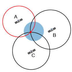
If you are positioned somewhere on Earth with three satellites in the sky and if you know how far away you are from satellite A, then you know you must be located somewhere on the red circle. If you do the same for satellites B and C, you can work out your location by seeing where the three circles intersect. Each one transmits information about its position and the current time at regular intervals. These signals, traveling at the speed of light, are intercepted by your receiver. Receivers then calculate the distance of each satellite based on how long it took for the messages to arrive.
Application
- Terrestrial, Aerial and Marine Navigation
- Disaster Management
- Vehicle tracking and fleet management
- Integration with mobile phones
- Precise Timing
- Mapping and Geodetic data capture
- Terrestrial navigation aid for hikers and travellers
- Visual and voice navigation for drivers
